A tree farm near Pedee
The homestead story that wasn’t.
Sullivan Tree Farm: Sections 28 and 33, Township 9 South, Range 6 West, Willamette Meridian, west of Pedee, Polk County, Oregon · See the Surveyor’s Walk card
“Was this land homesteaded around the turn of the century, the way the old management plan says?”
Written by AI
The Sullivan Tree Farm is 211 acres of woods west of Pedee, in Polk County, Oregon. For years its management plan said the land was homesteaded around 1900. So we read the oldest papers there are: the surveyors’ notes and maps from the 1850s. Only about 7 acres turn out to be homestead land. The rest has an older story. Family stories are like fence lines: handy, but not always where the surveyor put them.
What the record shows
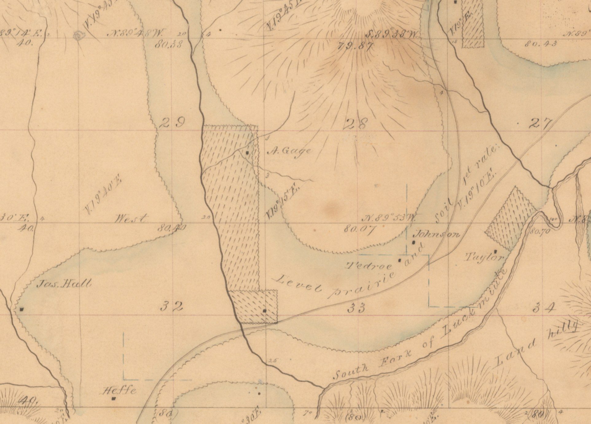
In March 1854 a government surveyor named Daniel Murphy walked the lines around this land and marked the corners. He was not alone out there. His notes point his compass at settlers’ houses, like Mr Tedroe’s, and one of his posts landed right in Mrs Gillam’s dooryard, 39 links (about 26 feet) from her house.
“Mr Tedroe’s dwelling bears S 51½° W.”
Source: Murphy, Daniel. Field notes of the subdivision of T. 9 S., R. 6 W., Willamette Meridian, 1854–55. BLM Oregon State Office, vol. R0029 (as transcribed in the landowner’s own history of the farm, October 2026)
Report an error
The map made from Murphy’s notes was approved on May 1, 1855. Little black squares on it mark settlers’ houses, labeled Tedroe, Johnson and Taylor. Across Section 33 it says “Level prairie and soil 1st rate.” In other words: flat, open grassland with very good soil.
“Level prairie and soil 1st rate.”
Source: General Land Office township plat, T. 9 S., R. 6 W., approved May 1, 1855. BLM Oregon State Office (as transcribed in the landowner’s own history of the farm, October 2026; see the first picture above)
Report an error
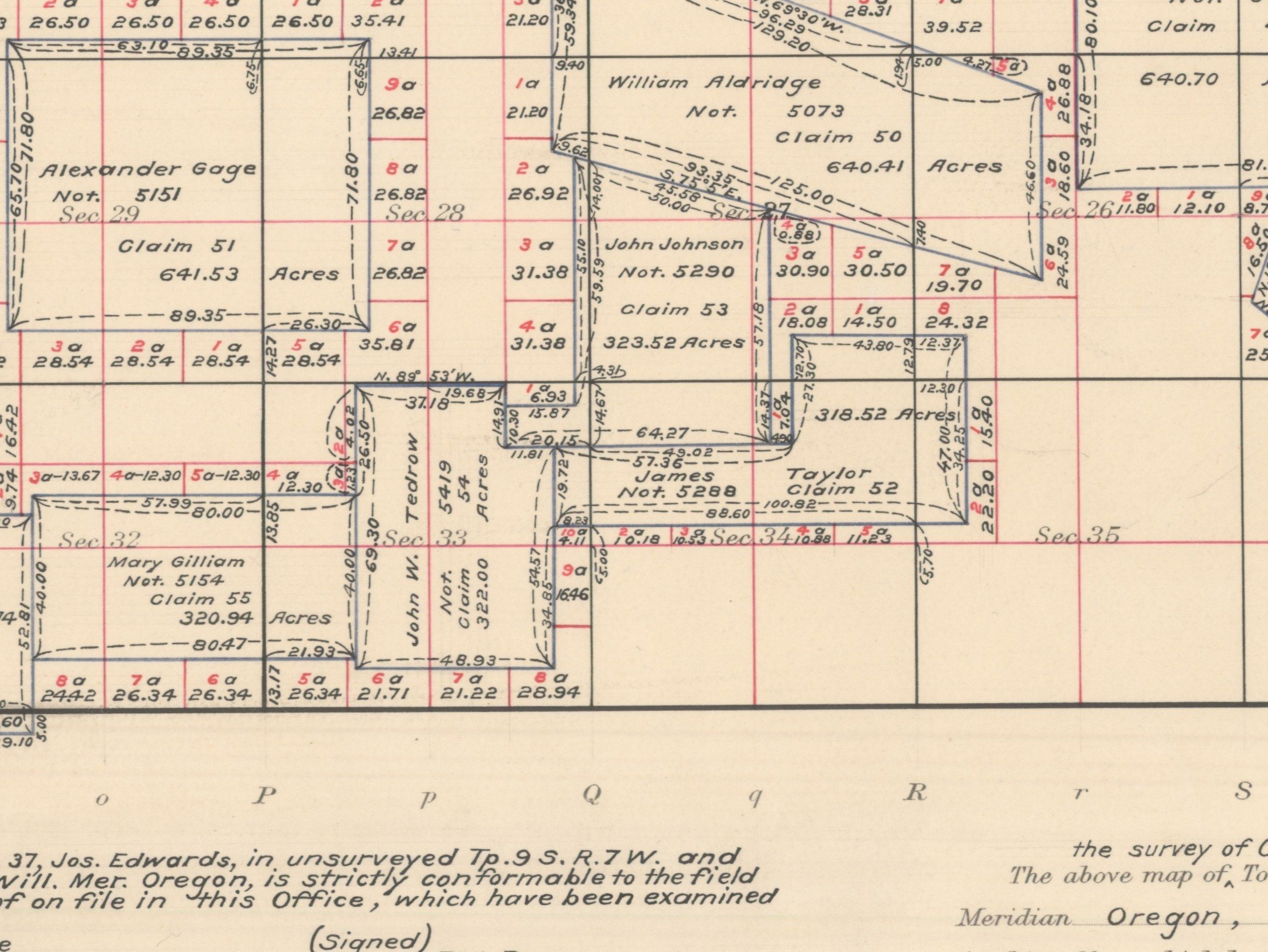
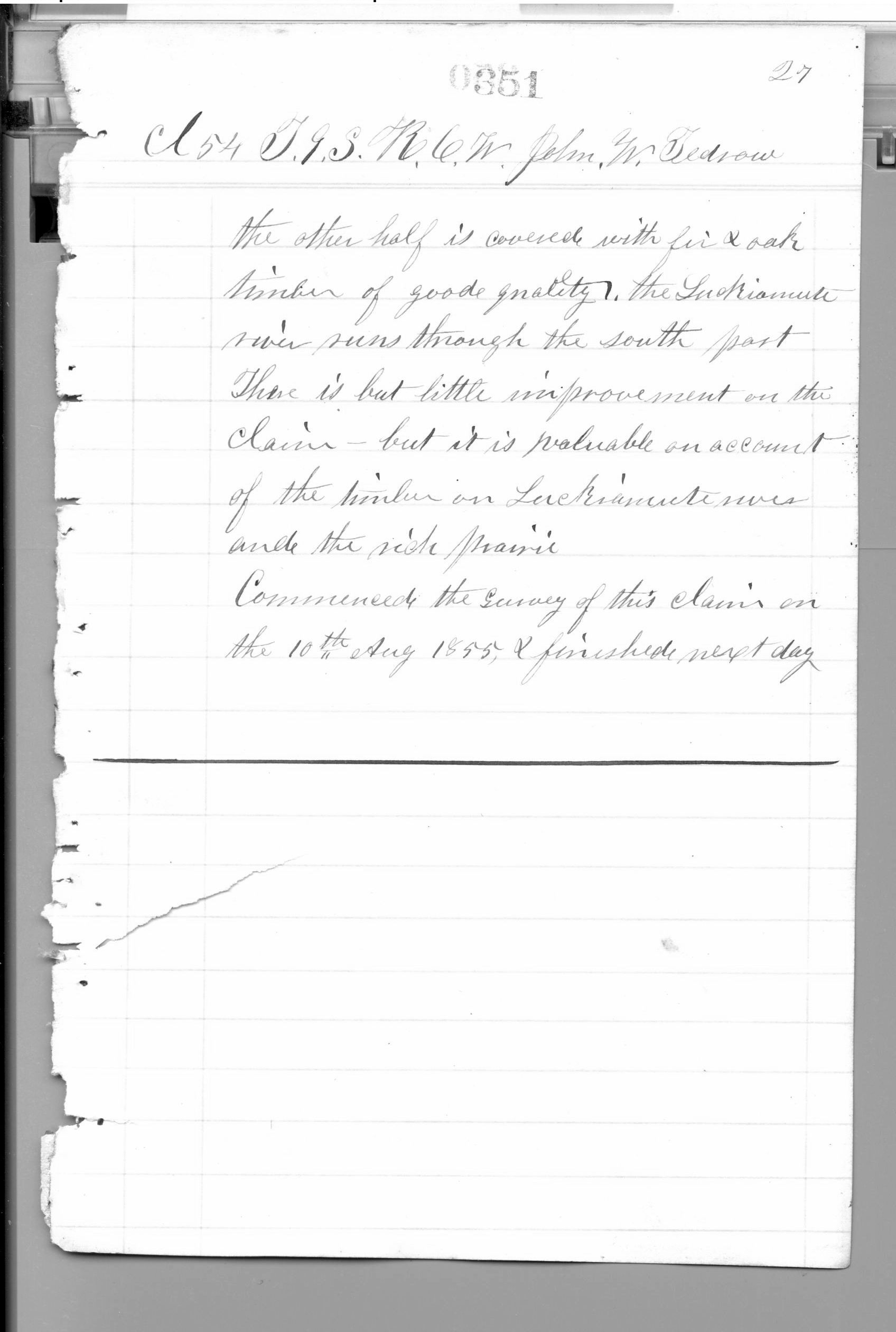
Some settlers held their land as Donation Land Claims, and each claim got its own survey. In the summer of 1855 a surveyor named Thomas H. Hutchinson measured three of them: Mary Gilliam’s in July, John W. Tedrow’s in August and John Johnson’s in September. A government list says 1856, but his own notes say 1855.
“10th Aug 1855”
Source: Hutchinson, Thomas H. Field notes of the Donation Land Claim surveys, T. 9 S., R. 6 W., 1855. BLM Oregon State Office, vol. D0022 (as transcribed in the landowner’s own history of the farm, October 2026; the date line is on page 351, the third picture above)
Report an error
About 150 of the farm’s acres are part of Claim No. 54, the 322 acres of John W. and Rachel Tedrow. Hutchinson wrote that their claim had little improvement yet, but was valuable for its timber along the river and its rich prairie.
“There is but little improvement on the claim — but it is valuable on account of the timber on Luckiamute river and the rich prairie.”
Source: Hutchinson, Thomas H. Field notes of the Donation Land Claim surveys, T. 9 S., R. 6 W., 1855. BLM Oregon State Office, vol. D0022, page 351 (as transcribed in the landowner’s own history of the farm, October 2026)
Report an error
About 12 more acres, on the east side, are part of Claim No. 53, John Johnson’s 323.5 acres. Hutchinson wrote that his claim was three fourths rich flat prairie and one fourth timber, and highly improved. Johnson even had a new barn.
“Three fourths of this claim is rich level prairie, one fourth is timbered. The claim is highly improved.”
Source: Hutchinson, Thomas H. Field notes of the Donation Land Claim surveys, T. 9 S., R. 6 W., 1855. BLM Oregon State Office, vol. D0022 (as transcribed in the landowner’s own history of the farm, October 2026; page not given)
Report an error
Hutchinson measured from one corner to two houses. Tedrow’s house was 66 feet away. Johnson’s house was about 396 feet away. Drawn on today’s map, both spots fall inside the farm, only about 400 feet apart. Nobody has gone to look for them yet.
“Tedrow’s house”
Source: Hutchinson, Thomas H. Field notes of the Donation Land Claim surveys, T. 9 S., R. 6 W., 1855. BLM Oregon State Office, vol. D0022 (as transcribed in the landowner’s own history of the farm, October 2026; house sites plotted there on Polk County map layers, approximate)
Report an error
At most corners the surveyors marked nearby “witness trees” (bearing trees). At 13 corners on and near the farm they wrote down 23 trees: 11 white oak, 4 more oaks of an unnamed kind, 2 ash, 2 alder, 2 cherry, 1 willow and 1 red fir, their name for Douglas-fir. That is 15 oaks and just one Douglas-fir. The surveyors picked these trees, so they are a small sample, not a count of the whole woods.
Source: Murphy, Daniel. Field notes of the subdivision of T. 9 S., R. 6 W., Willamette Meridian, 1854–55. BLM Oregon State Office, vol. R0029; Hutchinson, Thomas H. Field notes of the Donation Land Claim surveys, T. 9 S., R. 6 W., 1855. BLM Oregon State Office, vol. D0022 (the tally of 23 bearing trees as counted in the landowner’s history, October 2026)
Report an error
This land left the government’s hands through five papers called patents, probably six. The two claims got theirs in 1877. About 31 acres on the west side went to the Oregon & California Railroad in 1897 and 1899. A strip of about 7 acres may have gone to the same railroad in 1871, but nobody has read that paper yet. All the pieces add up to about 207 of the 211 acres.
Source: BLM General Land Office Records (land patents) and BLM Historical Index, T. 9 S., R. 6 W. (looked up by the landowner; as transcribed in the landowner’s own history of the farm, October 2026)
Report an error
Here is the only homestead land on the farm: a thin strip about 138 feet wide along the north edge, in Section 28, about 7 acres in all. Charles W. Pagett got a homestead patent for 104.35 acres there on October 12, 1900, and the farm takes in the south edge of it. Three earlier tries to homestead that land, in 1881, 1886 and 1887, were all cancelled, the last in October 1894. The list does not say who made them.
Source: BLM General Land Office Records (land patents) and BLM Historical Index, T. 9 S., R. 6 W. (looked up by the landowner; as transcribed in the landowner’s own history of the farm, October 2026)
Report an error
Here is the catch that Bob Zybach spotted. The law that gave out Donation Land Claims only ran until December 1, 1855. The Homestead Act came later: it became law in 1862, and people could start homesteads in 1863. So the claims surveyed in 1855 could not be homesteads. Only the thin strip from 1900 is.
“extended and continued in force until the first day of December, eighteen hundred and fifty-five”
Source: Act of Feb. 14, 1853, ch. 69, § 5, 10 Stat. 158; Homestead Act of May 20, 1862, ch. 75, 12 Stat. 392 (entries from January 1, 1863) (Homestead Act scan: govinfo.gov, STATUTE-12-Pg392; Dr. Zybach’s point as reported in the landowner’s history)
Report an error
Later the land kept changing. Cattle grazed it. About 1976 a company called Publishers Paper planted Douglas-fir seedlings in the open places, each in a tube to keep the deer off. In the spring of 1989 another company, WTD Industries, logged nearly all the big timber. In 1990 the bare ground was planted again: about 25,000 Douglas-fir seedlings, and then about 25,000 more.
Source: Sullivan Tree Farm Management Plan (2012), as summarized in the landowner’s history (October 2026) (the history notes that the plan’s word “homesteaded” is wrong for most of the land)
Report an error
Photos taken from airplanes show the land in 1936, 1955 and 1978. In 1936 it was a patchwork of dark tree clumps and open ground. In 1955 it was open grass with scattered trees. In 1978 the young planted trees were coming up. The photos are free on Oregon Digital. They only line up with today’s map to within 100 to 250 feet, so they show what grew where, not exact corners.
Source: USDA aerial photographs, Polk County, 1936–1978, in Oregon Digital, “Aerial Photos, Mid-Willamette” (Oregon State University) (as transcribed in the landowner’s own history of the farm, October 2026)
Report an error
What the record can’t say
Written by AI
- Gap in the record Who bought the land from the first owners and the railroad, and how the pieces came together, is still a mystery. The county’s old deed books have not been opened yet.
- Gap in the record Whether the 1871 railroad paper really covers the 7-acre strip is a guess. Nobody has looked at that paper itself.
- Gap in the record Every spot on these maps was drawn from a county map, not measured on the ground. Nobody has walked to the old house spots with the notes yet, and most of the witness trees are surely long gone.
- Gap in the record Who the Tedrows and the Johnsons really were is not settled. The family stories are unconfirmed and disagree in places, and which John Johnson held Claim 53 is a good guess, not a proven fact.
- Gap in the record People lived in this country before the surveyors came. The papers used here say almost nothing about them. The Kalapuya are the Native people generally linked with the Willamette Valley, but that is about the whole region, not this land, and their story is not told here.
What to look up next
Written by AI
Now try your own place Bring boots; the corner posts won’t come to you.